So, are you saying that non-civilians are excluded from the target market for PL? 
1 Like
When I took an image that had GPS coordinates set (externally using Geosetter) and then altered them to 0, 0, 0 (Longitude, Latitude and Altitude) the “See on map” remained active (i.e. not greyed out) and selecting in resulted in a Google Maps display as expected (the Atlantic Ocean, south of Ghana and west of Gabon).
…well, somehow, DxO’s geolocation UI is a arthropodarium
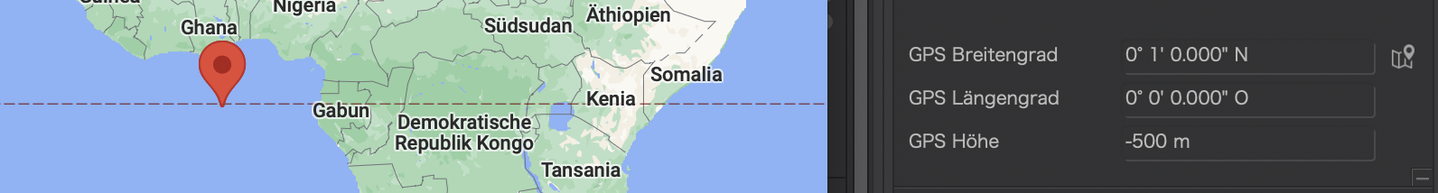
(not sure how deep the ocean is at those coordinates)
Excluding “0” is one of the most basic programmer’s errors 
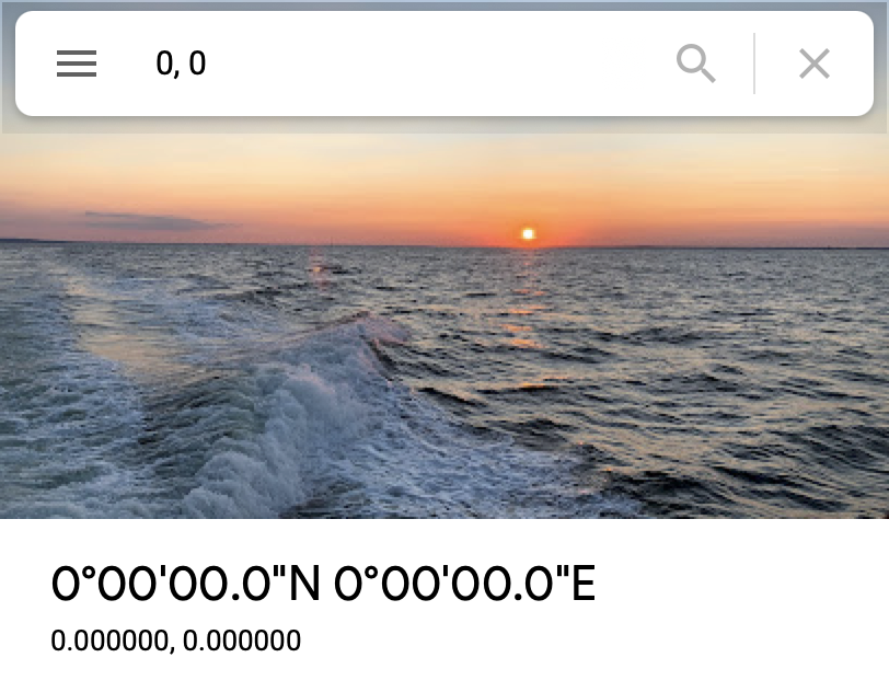
Google can do (or fake) it:
1 Like
I was able to enter 0 for altitude, and after navigating away to another image and back to the image the metadata display still shows 0m. This on the Windows version of PL5.
Nope that was the “19” of 1989 in date’s.
The saving of 10011 or hex 13 in the date did costed the world biljoins of dollars…

That is correct, Peter, but in defense of those of us who wrote that code in the '70s and early '80s, none of us even remotely anticipated that a lot of that software would still be in use 20 years later.
By the early '80s we were well aware that date format would be an issue when the year 2000 arrived, (which by the way is actually the last year of the 20th century not the first year of the 21st century which was conveniently ignored by almost everybody.)
The reason that nothing was done to correct this very old software earlier was because large amounts of it were in the process of being replaced or was scheduled to be replaced well before the year 2000. However, schedules change for various reasons and, much of this software continued to be used up to the year 2000 anyway.
Even software that was not scheduled for replacement at that time was not modified 10 years in advance or even 5 years because the cost would have been prohibitive especially if the software was likely to be replaced before the year 2000. As it turned out, far more software with the date issue survived to the year 2000 than anyone anticipated. In addition a lot of the work done to resolve the year 2000 date issue was divided between modifying the date structure in the existing software and replacing the software all together.
The skills needed to update so much very old mainframe software was a challenge because there weren’t enough resources available who understood this older technology. As a result a lot of retired programmers were called in as consultants at great expense. Anyone with any experience at mainframe programming was ensured a year or two of work at a very comfortable salary.
I spent 18 months of my life doing almost nothing but mitigating this problem as part of my responsibility as a software development manager at JPMorgan Bank in New York City.
Mark
1 Like
More suggestions:
- It should be possible to select multiple images (in either PhotoLibrary or Customize) and have all locations sent to Google Maps.
- Currently this is a ‘read only’ function. Being able to change coordinates via a map would be a useful addition.
An option to switch map providers would be useful and might also save DxO some money (I expect they have to pay Google for each use of the map service).
This is a really (really) complex topic. For example, each image has two coordinates (camera and object shown), altitude vs. elevation, FOV. Selecting images by defining an area. A can of worms.
hi Mark,
Yes i understand, it was based on hardware restriction of the early computers, databus of 8 bits, and storage of data was expensive because the “memory” needed a lot of electric power and due heat issue’s they died alot in the mainframe’s.
When the z80 became the 8088 that was the moment to switch, but microsoft was until the 80386 dragging his feet in rewriting windows and all other software was depending on there OS. Lots of the database applications of financial world where dinasors stacked with “patches”.
I do not envy the retired developers at those times, ok nice money but lot of stress.
Luckaly you survived. 
1 Like
I’m sorry but i didn’t click on the dedicated icon. I see it now with platypus screenshoot…Thank you
ok did the update, yes i know late to the party but i am busy.
small test:
open googlemaps find a place, copy coordinates and paste them in dxopl GPS latitude.
nope, red warning no automatic split of latitude and longitude.
So i have to do this myself.
paste, delete one section, paste delete the other section.
second: click on “map icon” yes i am pointed at the same spot.
Question for DxOStaff, How difficult is it to implement the auto split of the latitude and longitude data which you can copy from maps?
" 64.64784871931667, -17.29737759191865 "
it does translate the google coordinates to degres like 64° 38’ 52" N and 17° 17’ 51" W So that part is working.
i would like a single copy paste action from maps to dxopl’s metadata if it’s possible.
That’s my suggestion here:
1 Like
I will also support that point. Let the user choose in the settings which map system he/she wants to use (Google, Apple, OpenStreetMap are the most common).
@StevenL
Should this be an option as well ?
Do you sometimes want to compare images (maps in this case) ?
Well, I do take a lot of images from motorcycle tours. For me it would be better with more markers on the same tab than a tab for each image.
1 Like
One consideration that DxO has to take into account is that Google and most other map vendors (not OpenStreetMap) charge fees for location lookups. The issue for DxO is whether to eat this cost or figure out a way to pass the cost on to users. It’s less of an issue for very large companies (e.g., Adobe) but may be a significant cost for smaller ones. One alternative is have users use their own keys from Google, etc. (most map vendors allow a certain number of lookups a month; that number is reasonable for most individual users). How users would react to this extra complexity is another issue.
When i just look up a place and rightclick to get the coordinates i can copy past them in dxopl. For free. And i suppose when you use a commercial tracker you have software to connect shottime of the rawfile with the gps place and time of the tracker.
Creating xmp’s or writing inthere. (which is again a breach in integrity of the xmp because of non excisting standards and strickt rules in how you write in a xmp. But that’s an other story.)
The new button to go to filled in gps data on googlemaps is also free right?
So for what should dxo need to pay? A integration mode like i click on empty gps line and it opens googlemaps and i navigate to a certain point and drop a pin which activates the entry of those coordinates?
Google (and other map providers) spend large amounts of money collecting and updating their map data. Not surprisingly, they expect to monetize use of this data. For individual users, they collect information on who/what/were/etc. and use or sell this information (i.e., you are the product they’re selling). For corporate users, they’ve established an API for using this data, with various restrictions and costs (for details, see Google Maps Platform FAQ | Google Developers). The API is needed for things like location lookups, reverse geocoding, etc. (Simply embedding a map on a website without any programming or use of the Google Maps Platform is allowed for free, so if you want a Google Map on your own website, that’s OK. But if you require programming or use of the Google Maps Platform, there’s a cost.)
1 Like