Hé toi ! C’est mon territoire ! Tu connais Perros Guirec ? Et la mer ne penche pas comme ça 

Hang on a minute! Is this Mr PhotoJournalist speaking? What happened to “if it’s there it has to be in the shot”?  But seriously, I did try to avoid it but any other angle wouldn’t have got the right framing of the tractor within the shed. And, at least, the reflection is on ly of the sky instead of a load of detailed stuff.
How to ruin a perfectly good photo. Since it only takes a matter of minutes for someone to clone it out, I’m never going to bother.
That’s just what a good landscape image should do - capture the viewer.
I couldn’t do B&W as I like it without my trusty Fuji Acros 100 from FilmPack.
What’s with all the boats on the wrong side of this “barrier”?
Where’s the kid ready to stick his finger into any holes that open up in the “barrier”?
India doesn’t seem to have any issues like these. I did spend some time in Holland, and photographed some of the boats in the “canal” if that’s the correct term. I wish I had had more time to just wander around, but I’d probably have gotten lost.
Oh, and what is the “cross” at the top of the poles? Does it light up at night?
The barrier is there to keep the sea in at low tide, otherwise all the boats would tip over on their keels.
Here is a satellite view…

They are marker poles to let boats know where the sea wall is, and they don’t light up.
According to this source the worst differences in tides are said to be found in Nova Scotia in Canada where it´s said to be about 12 meter or 40 feet.
Where is the highest tide? (noaa.gov)
In a country like mine where the water surface has been sinking (or the land rising the last 10 000 years) the land elevation rate is around 500mm in 100 years in the Stockholm area. In the north where the ice cap was about 2 km thick 10 000 years ago the land is now rising with the double speed of the amount in Stockholm which makes about 1000 mm in 100 years. So that have forced some towns in the north to abandon their old habors from time to time.
In the south end of our long coastline the land is sinking of the same reason and there they are building walls right now. That effect has to be added to to rising surface levels due to climate change.
Today the land elevation (-) and the raising water surface (+) is even out so for the moment Stockholm is not affected at all by rising sea levels due to climate change.
In Stockholm the level of the old city wall where the water stood in medieval times now is more than 3 meters higher than the present sea level. The problems with the increased flows into the lake behind the locks is the reason to why the locks i Stockholm has to be widened and not that rising levels of the sea - at least not for now.
One fantastic effect of the elevation of the land after the last Ice Age is that we have got around 30 000 islands that have rised slowly above the sea level where the top constance of the islands rarely rises more than 25 meters. These islands stretches in a long band from north to south about 250 km after the coast and thousands of other islands also scatter the lake Mälaren from east to west beginning in the city itself which is built on quite a few separate islands. Stockholm was once built as a fortification to protect the densely populated and importanty inland around the Lake Mälaren.
That can be easily remedied by removing it of course, but I know that wouldn’t be acceptable to you.
Here is a very quick and not very neatly done removal of the mailbox to give an idea what the image might look like with it removed. With a little more effort I could have made the transition much neater. With apologies to @Joanna. 
Mark

1 Like
Accepted, but don’t do it again without written permission from Mike 

1 Like
Puzzled - I see no way “out” to sea? I see where it says “the lock is to let boats in and out” - does that areal at the lower right fill up with water at high tide, and that’s how boats can enter or leave this protected area? Fascinating! This photo is worth a few hundred words. So obviously the photo was taken at low tide.
Naw, you can do anything you want, no permission needed. So can I, if I label it a “photo illustration”. In this case, I might have tried to move a few feet to the right before taking a photo. I don’t like the mailbox distracting me when I look at the photo. Maybe I’d have moved closer, and used a wider angle lens. I dunno.
Everything outside the wall is sea, all the way to England. Straight North for 100 miles.
Here’s a link to Google Maps
Mike, unless you’re selling the photograph to a service with specific standards, like National Geographic, or using it as a news photo, or submitting it to a contest with specific rules, there is no need to label it photo illustration or anything else for that matter.
For most purposes, it is just an image and should be judged on the effectiveness of the final result, not on how the final result was achieved. The image of @Joanna’s tractor in an old shed converted to monochrome is an artistic impression meant to create something poignant or sentimental which will elicit an emotional response from the viewer. Removing distracting objects can often turn less than perfect images into great ones. The final results should stand on their own merits and need no label and no explanation.
Mark
There’s no need to do anything one way or the other, but after a lifetime of doing things this way, I see no need to change. Apparently nobody cares any more, but I care. It doesn’t hurt anyone, so why not do things as I’m used to? Quite a few of the people who view my photos also care. Does it bother you if I do things my way? If not, what’s the big fuss.
I could have installed a larger engine in my 1/8 scale RC car, making it faster, but everyone running those cars used a .21 engine. Besides, the way to go faster had nothing to do with the engine in the car, but how skilled the person was driving it. My friends know that I don’t “cheat”, and the photo I send them is what I saw when taking the photo, as in “real”. I prefer “real”. I tried Luminar, and still have it, but that’s not the kind of photography I’m interested in. I figure though, that I’m free to do anything I want, even change the entire sky, if I label the photo accordingly, but to me, that’s too boring.
You can, of course, do anything you want to do with no recriminations from me. You just seem to spend a lot of time and effort differentiating “photo illustration” from photos and for most images in most situations it is just not terribly relevant and may actually get in the way of creating a great image.
Let us suppose that you wanted to capture the image of a still occupied house built in the mid 19th century with a look and a mood consistent with the period in which it was built. This might be impossible to achieve unless the satellite dish on the roof and phone and power lines, are first emoved. Those anachronistic features would not serve the intended purpose of the photograph, and in fact will ruin it.
However, based on your standards and approach which requires including everything you see in a photograph, you would not feel comfortable removing those objects and therefore would not be able to achieve the suggested goal. Of course, your goal may be different. You may want to show the passage of time and would prefer the inclusion of those anachronistic additions, Each approach is just as valid as the other.
Mark
Simple - if I take a photo of the house as it is right now, it’s a “photograph”. If I “fake” it to look like a picture from the mid 19th century, I call it a “Photo Illustration”. Problem resolved, either way.
“Photo manipulation is nearly as old as photography itself, but modern technology has made it common and easy to do. Using photo editing software, almost anyone can make big changes to an image, from adjusting colors and lighting, to adding and removing content. That’s why you should always keep a critical eye on images in the media.”
Most people who know me know that my photos represent “reality”. I’m satisfied with that. If I create art (meaning a fake photo), I label it as such, and go right ahead and play with the image.
Ansel Adams manipulated images beautifully, but they were all based on “reality”. That’s the kind of photography I would most like to achieve. But most of the time, I’m just trying to capture real life, around me. …unless I’m working to create advertising, or magazine covers, or other places where photo manipulation is expected, and nothing has to be “real”.
I’m not sure why we’re still discussing this. I’m not trying to change anyone else’s mind, and there’s no chance I’m going to change, unless I make it clear as to what I did.
Sure, my photos are one, or the other. There’s no time differentiating between them, any more than differentiating between a red barn and a green barn. My “rules” are posted here:
Photography Ethics for Photojournalists, and while I’m currently not a working photojournalist, I still accept the difference. I can do either, but I won’t pass “fake” off as “reality” (as I see things).
Yes, at the end of that dam. When I’m home from Sevilla I will check if I getagged the pictures. I wouldn’t know where it was.
@mikemyers when water is high that barrier is under water and that barrier is invisible. With these marker poles you know where it is. This is used in the Norwegian mountains too to make the road visible when it has been snowing. I think it counts for Sweden and other countries too.
George
Thanks - makes sense to me now. I never would have guessed!
You took the picture from the cale that I circled on the screenshot of Google Maps and I linked to the location in this post
@George What happens when the sea level rises and the barrier is invisible?
I live in Vaxholm a small fortified town that until 2005 was a naval base. Since houndreds of years there are barriers under the water between many of the islands around with very narrow passages even today. The barriers are just 50cm to a meter below the surface so you can´t see them many times because the visibility is often very low, especially in the summer and the barriers are also covered by dark sea weed. Still there are no warning signs what so ever. People are supposed to be able to use sea maps and navigate when they go out in the islands but I think that is to suppose to much.
At one place at a near bye island a guy who lives there counted over 40 accidents just during the first part of that summer when people accidently ran into these underwater barriers.
Some car people seems to believe that it´s just to keep in the middle between the islands to be fine. Even one of my neighbors guests hit that very spot a few years ago so bad that their 90 HP engine got both the propeller and gear case destroyed. He was from the south of Sweden where they don´t have any islands.
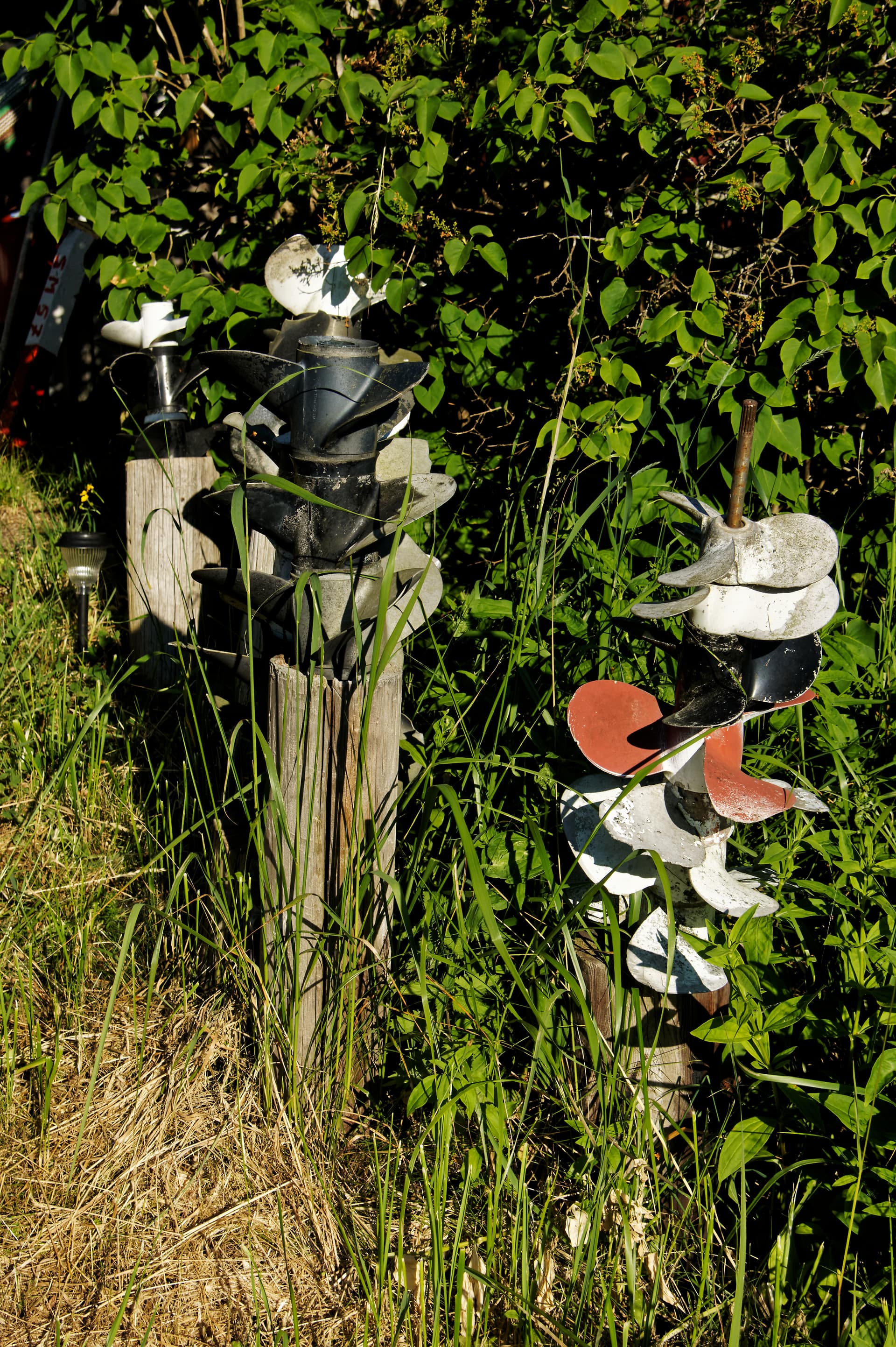
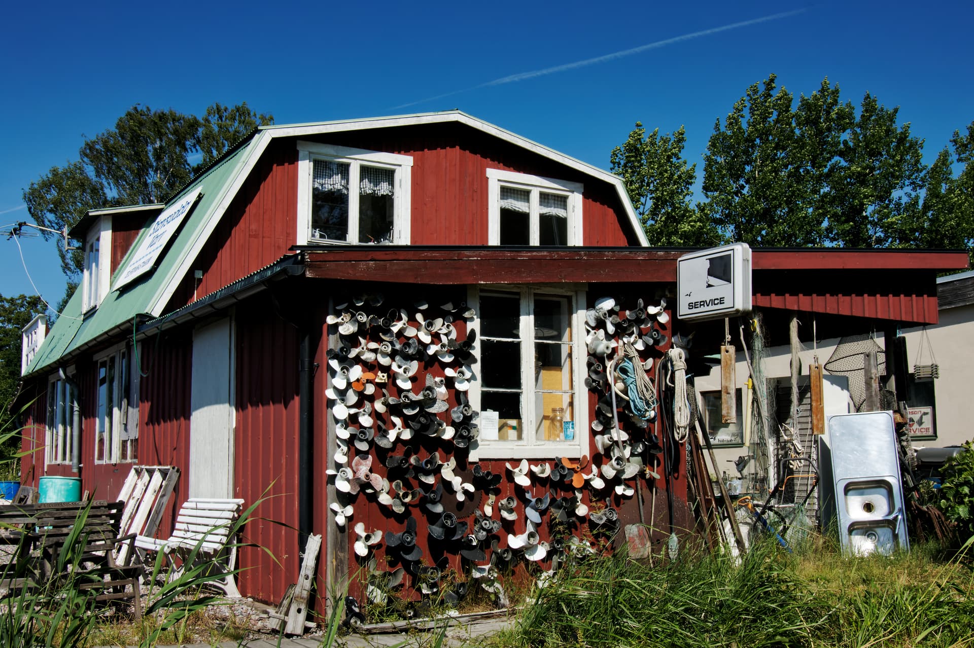
Navigating in Stockholm Archipelago has never been easy and as you can see from the wall of the service station at the island of Norra Stavsudda far out from Stockholm and Vaxholm there are a few even here that hit the underwater skerries and rocks.
And I´m not kidding writing this but in fact there is such an abundance of old destroyed propellers at Stavsudda that some of the locals are using them as some kind of permanent flowers in their gardens.
When I was 20 I was a racing boat navigator in a few races and there was a joke in these days among the navigators:
“It´s fine to go where the seagulls swim but NOT where they stand!”
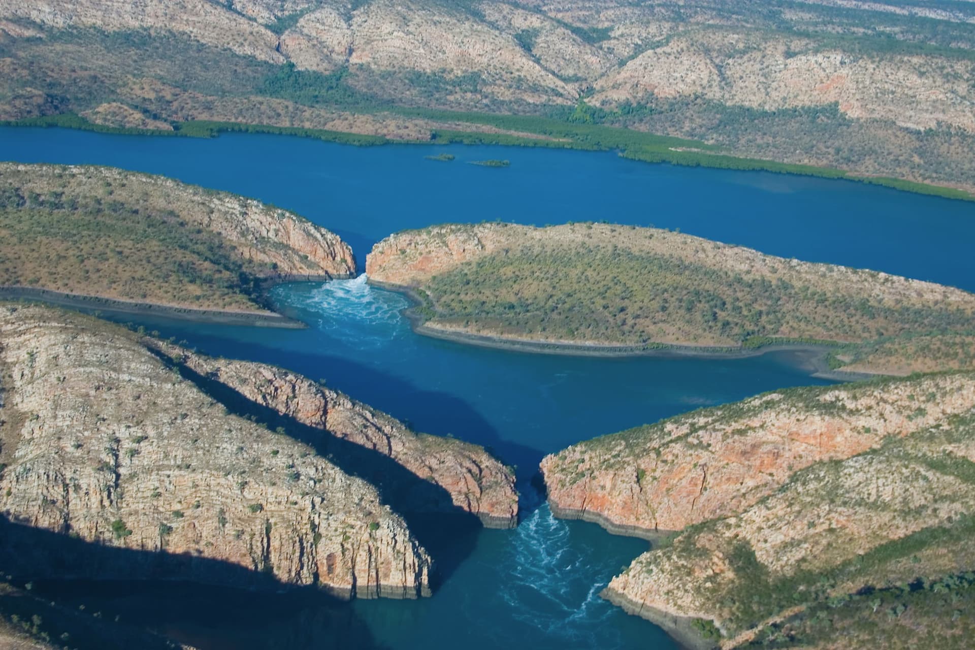
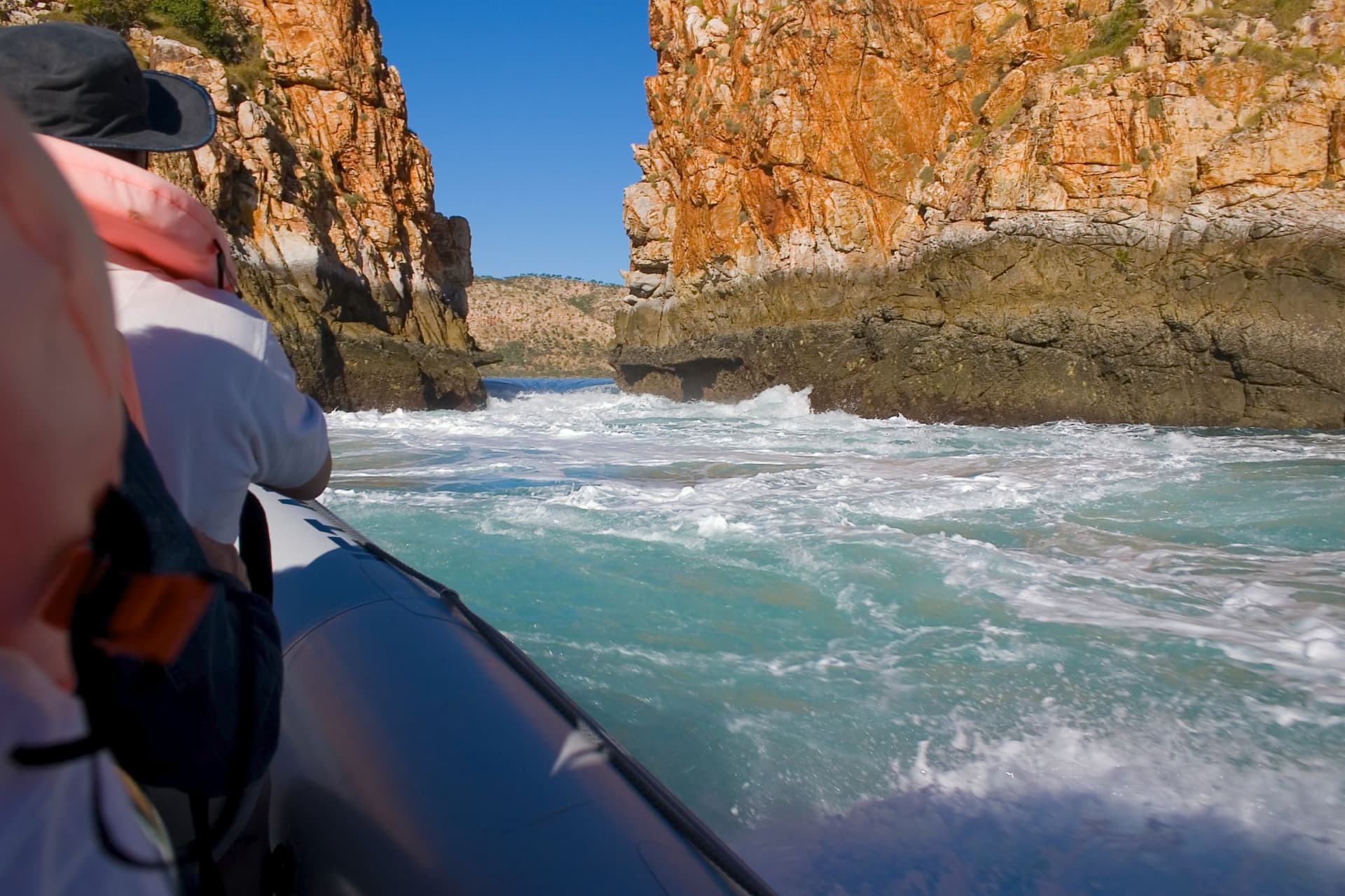
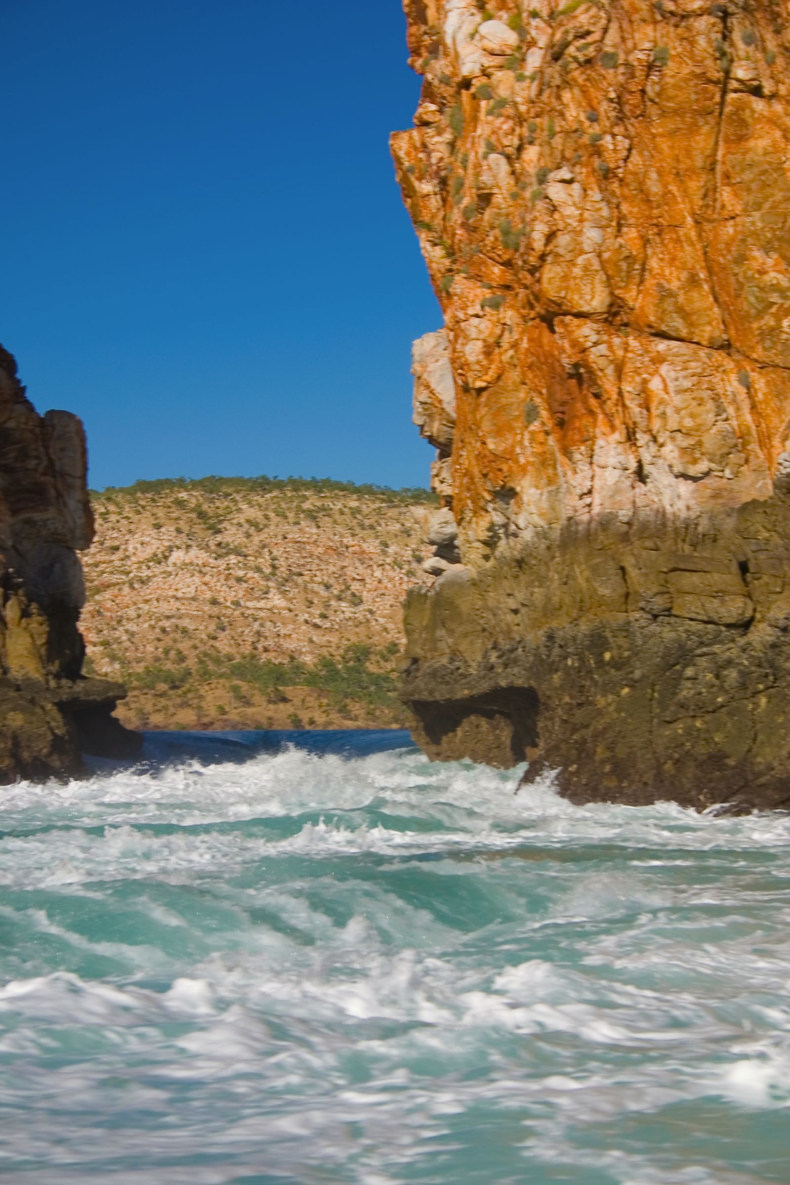
In western Australia we have a natural feature named the Horizontal Waterfalls which is created by a tide of approximately 12m.

2 Likes