It would be useful to be able to map multiple images on the same map (as lightroom does) As a journalist/documentary film maker I wil want to look at a grouip of images and see the locations on a single map as I could in lightroom.
GeoSetter is a good program for this. It works with OpenStreetMap (but no more with G…e, not free).
2 Likes
Don’t forget to vote for the proposal…
Pl users are really the “workers around” par excellence. Well, of course, what else can one do when the results of the patchwork-around-app themselves are great, but the features… “It has DeepPrime!” might be the excuse for everything else, I’m just not sure to live long enough to grow into it. 
Thanks for the complement, i think.
i always tell my boss that troubleshooters who are doing less work are good for the business and cheaper:
1 if don’t repair that means the machine is working and working means it produces pagecounts which is profit.
2 no repair means less parts i use to repair so no cost!
3 no repairs means customer isn’t waiting for me and is happy.
4 so me having a sun taint means i am a excelent mechanic!

(every time is tel him that and ask for a raise he’s bursting in laughter and shuts the door…  )
)
communication issue i think… 
1 Like
you can multiple select images and then add gps and it stores this on all selected images.
What i would like is a one click entry of coordinates provided by googlemaps (now we can click on maps to point to the location gps is showing vice versa would be nice)
And templates is also a thing which speed up the tagging and such.
I just think he’s to blind to see you have DeepPrime*. Or tried and heard something like “this Petter has DeepRession, poor guy…” Well, bosses are not bosses because they are good listeners.
2 Likes
My camera adds GPS, that is not the problem. I don’t need to add GPS to groups of images.
The problem is to be able to see a selection of images on the one map page. At the moment I am getting each image on a seperate map tab.
It’s in the name: Boss comes from “bossy”… 
1 Like
This one was good 
I also have one…
What is the difference between a company and the Eiffel Tower…at the Eiffel Tower are the biggest rivets below
1 Like
Well the audience liked it but would you please let us in on the joke with a translation? All I got was it was something about the crow and the fool - a joke that applies to many decision-makers (thanks to Deepl)
OK, I found translated subtitles and get it but I guess others might like to know
ok i did some “googlemaps” identification and GPS tagging with location and naming city.
(geesh i must be bored out of my mind to do this!)
any way, one thing start to be a thing of thought.
xmp is made by Bridge adnd when i refill in some aditional stuff the hierarchie is smutched.
Don’t know if it’s poking of two in one xmp or plain a problem.
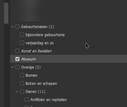
it makes in dxopl this:
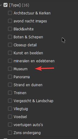
wile it should create this:
So this means i can’t do aditional info placing without ruining my original hieracy.
AND THIS IS REAALLY!!! BAD BECAUSE I CAN"T RUN EVERY TIME A SCAN IN BRIDGE FOR REPAIR!!! this costing me day’s to repair.